Why must we not allow a new catastrophe like the disappearance of the Aral Sea?
The desiccation of the Aral Sea is one of the largest environmental catastrophes of the 20th–21st centuries, caused by water withdrawals from the Amu Darya and Syr Darya rivers for irrigation. In place of what was once the world’s fourth-largest lake, the Aralkum Desert has formed, from where winds carry around 100 million tons of toxic salts and dust every year. Ahead of the Regional Ecological Summit 2026, experts from the Project Office for Central Asia on climate change and green energy of the Central Asian Climate Fund (CACF) analyzed publicly available information regarding the demise of the Aral Sea and other water bodies that may face a similar fate.
In the 20th century, before it began to dry up, the Aral Sea was the fourth-largest lake in the world by surface area (after the Caspian Sea, Lake Superior in North America, and Lake Victoria in Africa). In 1960, its level was 53 meters, its volume was 1,066 km³, its surface area was 66,000 km², its salinity was 10 g/L, and the length of its shoreline exceeded 4,430 km. An underwater ridge stretching from north to south divided it into a deep western part (up to 69 m) and a shallow eastern part (maximum 28 m). They were connected by the wide and deep Berg Strait and the narrow, shallow Auzy-Kokaral Strait. The water area included about 1,100 islands with a total area of 2,235 km², of which 1,585 km² were periodically flooded. Its ichthyofauna comprised about 200 species of invertebrates and 32 species of fish.
Two-thirds of the Aral Sea’s water resources were formed in the Amu Darya system, and one-third came from the Syr Darya.
History of the demise
The degradation of the Aral Sea began in the 1950s in connection with a new economic strategy of the Soviet Union, which required cotton for light industry, the production of munitions, and rocket fuel. Central Asia was an ideal region for its cultivation. Turkmenistan, Uzbekistan, and southern Kazakhstan—then part of the USSR—became its “cotton breadbasket.” Water from the Amu Darya and Syr Darya river basins was used to irrigate plantations.
Until the 1960s, water withdrawals were compensated by return flows from collector-drainage networks. In the 1960s, the area of irrigated land reached 4.7 million hectares, including 2.2 million hectares planted with cotton. Intensive water withdrawals from the Amu Darya and Syr Darya basins disrupted the balance of the Aral Sea system, and it began to dry up. By the end of the 1960s, inflow to the sea had decreased by 8 km³/year; an additional burden was the natural low-water conditions of several years. As early as the late 1960s, the Auzy-Kokaral Strait dried up.
By the late 1970s, the Syr Darya’s flow no longer reached the Aral Sea; by the end of the 1980s, the waters of the Amu Darya also ceased to reach it. Between 1971 and 1985, the growing imbalance between inflow and losses led to a sea-level decline of 67 cm per year, totaling more than 20 m since the 1960s. During this period, the first calls to stop the desiccation began to be heard, and the possibility of replenishing the Aral Sea by diverting Siberian rivers was considered.
In 1985–1986, the Aral Sea level fell to the critical mark of 41 m, after which it split into two isolated water bodies: the Northern (Small) Aral, with an area of about 3,000 km² into which the Syr Darya flows, and the Southern (Large) Aral, into which the Amu Darya flows. The water level in the latter continued to decrease by 50 cm per year, and it became progressively more saline.
After the collapse of the USSR, a temporary reduction in withdrawals from the Syr Darya led to water again entering the Berg Strait and flowing from the Small Aral into the Large Aral. By the end of May 1992, 100 m³ of water per second was passing through it, and a tendency toward erosion emerged. The deepening channel could have reached the mouth of the Syr Darya and triggered the river’s diversion from the Small Aral into the Large Aral, which would have led to the desiccation of the former.
In 1992, a sand dam was built around the city of Aralsk to protect the Small Aral from further drying. A natural rise in water at the beginning of 1993 washed it away; a new dam was built in 1997. It was destroyed in 1999 when the Syr Darya flow increased. In its place, by 2005, the Kokaral Dam was built with funds from the World Bank, thanks to which the absolute water level in the Small Aral rose to 42 m. The water freshened, a new composition of ichthyofauna formed, and industrial fishing was revived.
By the end of the 1990s, the area of irrigated lands under cultivation had increased to 7.4 million hectares. Eighty reservoirs with a combined volume of 100 million m³ were created, and the total length of the irrigation network reached 315.8 thousand km. At the same time, the rationality of water use was extremely low-irrigation was conducted without proper accounting, huge losses occurred at all stages, and as a result no more than 50% of withdrawn water reached the fields.
From 1960 to 2016, the total surface area of the Aral Sea (counting the Large and Small Aral together) decreased ninefold, and total volume fell twenty-onefold. Today, the former Aral Sea consists of several isolated water bodies.
According to modern estimates, human economic activity accounted for more than 70% of the Aral Sea’s drying, while climatic factors contributed less than 30%.
Catastrophic consequences
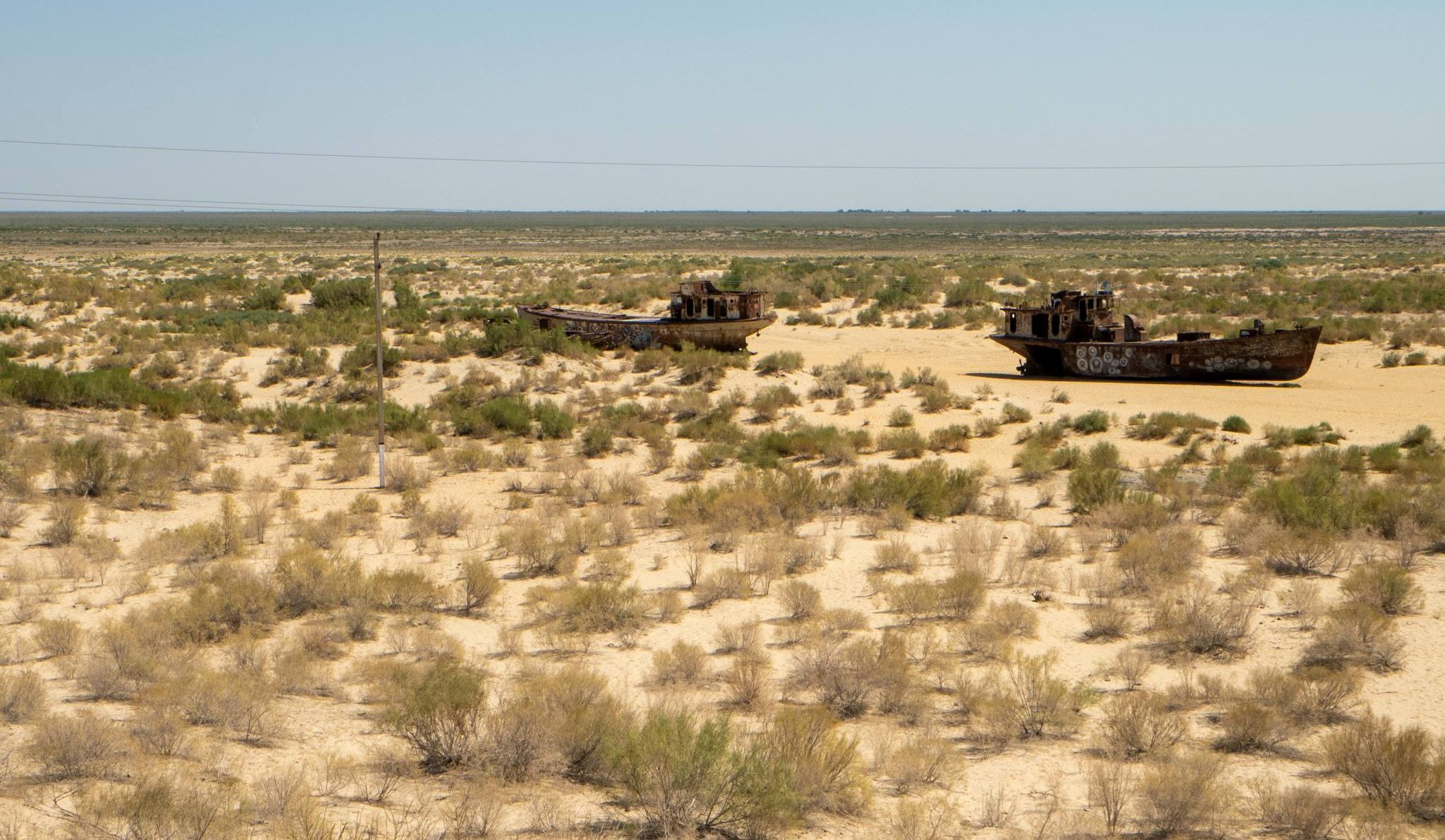
In place of the vanished sea, a new salt-and-sand desert-the Aralkum-formed, covering about 6 million hectares, of which 3.2 million are in Uzbekistan and about 2.8 million are in Kazakhstan.
The climate in the Aral Sea region became more continental: summers became drier and hotter by 2–2.5 degrees, and winters colder by 1–2 degrees. Within a radius of up to 100 km, atmospheric precipitation decreased severalfold.
Salt deposits on the dried bottom of the Aral Sea contain large amounts of pesticides, herbicides, and fertilizers used in irrigating cotton fields and subsequently carried into the sea by river or groundwater runoff.
During strong winds, which occur in the Aral Sea region 30-50 days per year, large-scale dust storms develop: the dust plume reaches 600 km in length, and particle uplift heights reach up to 4 km. Scientists note that the intensity and frequency of dust storms in the Aral Sea region increase every year. Each year, winds carry up to 100 million tons of salt, sand, and toxic chemicals from the Aralkum, poisoning soil and air for hundreds of kilometers around. Powerful jet streams moving from west to east transport aerosol mixtures of dust and salts from the former Aral Sea bed to the surfaces of glaciers in the Tien Shan and Pamir, intensifying the already active melting driven by global climate change.
Toxic salts from the Aral region have been detected in the blood of Antarctic penguins, on Greenland’s glaciers, and also in the forests of Norway, the fields of Belarus, and elsewhere.
Salt-dust aerosols, depending on particle fraction, can remain in the air from 1–3 days (coarse particles) to several months (fine particles). Inhalation has an extremely negative impact on the health of people and animals.
Among residents of the Aral Sea region, the prevalence of eye and respiratory diseases, anemia, diabetes mellitus, and malignant neoplasms is increasing. Since the 1960s, the incidence of ischemic heart disease has increased 18-fold, pneumonia 19-fold, and chronic bronchitis 30-fold. Deteriorating drinking water quality has led to growth in kidney stone disease: among rural residents of Karakalpakstan, incidence increased 4.2-fold. Extremely high levels of child mortality and morbidity are recorded in the Aral Sea region. According to scientists, at least 46.4% of respiratory diseases in children are caused by air pollution with sulfates due to dust storms; for adults, this figure is 38.9%.
Until the mid-20th century, the Aral Sea had 32 fish species, 10 of which were introduced artificially to increase commercial catches. Endemic species included the Aral barbel, bream, common carp, asp, roach, pike, catfish, and pikeperch, accounting for up to 85% of the catch. With increasing mineralization, by 1970 all of them became extinct, severely affecting the fishing industry, which employed more than 60,000 people. By the late 1980s, port towns (Muynak in Uzbekistan and Aralsk in Kazakhstan) were left tens of kilometers from the water; the collapse of fisheries caused mass unemployment among local residents. Since 2004, there has been no fish left in the Large Aral at all.
Changes in the Aral Sea’s water supply regime triggered an entire chain of transformations affecting the ecosystems of the Amu Darya and Syr Darya basins. The sea had a climate-forming effect within a zone up to 200 km from the coastal strip. By 1974, 30 lakes with a total area of 7,000 hectares had dried up, and reed beds shrank from 600,000 hectares in 1961 to 100,000 hectares. Meadow-marsh soils previously occupied by reeds became salinized. Tugai forests died due to falling groundwater levels. Of 173 animal species, only 38 survived, and their populations are extremely vulnerable.
Since the 1980s, throughout the Aral Sea region, salinization and soil pollution due to dust transport from dried areas of the former seabed led to declining productivity of agricultural lands. By 2017, salinity levels in the Muynak district of Karakalpakstan reached 96%; in other districts of the republic, they exceeded 80%, and yields fell by half. In Kazakhstan, grain quality has deteriorated year by year; from the 1990s to 2019, the area under agricultural crops decreased by 40%.
The lack of jobs and worsening living conditions led to forced migration of the population.
Current state of the Aral Sea
Thanks to measures taken by Kazakhstan and inflows from the Syr Darya, the state of the Northern Aral has stabilized and shows positive dynamics. The volume of water has reached 23 billion cubic meters.
Reduced salinity has led to the recovery of freshwater fish populations. Today, the water body contains more than 20 species, about 14 of which are commercially valuable. Annual catches reach 8,000 tons.
Phytomelioration continues on the dried bottom of the Aral Sea through planting saxaul. In 2025, the area of green plantations reached 1 million hectares.
The Southern Aral remains in critical condition; the water volume decreases every year.
According to the scientific community, it is impossible to restore the Aral Sea to its former volume.
Where could the Aral tragedy repeat?
At present, the state of the Caspian Sea is of particular concern. The largest enclosed water body on the planet, a legacy of the ancient Tethys Ocean with a unique ecosystem, is disappearing before our eyes. In less than 20 years, the surface area of the Caspian Sea has decreased by more than 34,000 square kilometers. For comparison, this is larger than the area of one of Africa’s largest lakes-Lake Tanganyika (32,900 km²)-or Belgium (32,545 km²), and larger than the territories of 138 countries worldwide. In addition, water quality in the Caspian has shifted from clean to moderately polluted, with periodic recorded exceedances of maximum permissible concentrations of harmful substances. Read more here.
A truly catastrophic situation is unfolding at Lake Chad. Since the 1960s, the area of one of Africa’s largest water bodies has shrunk by more than 90% (from ~25,000 km² to less than 2,000 km²) due to climate change, droughts, and excessive water use for irrigation. Falling water levels threaten the lives of more than 40 million people in Cameroon, Niger, Nigeria, the Central African Republic, and Chad, posing risks of ecological and humanitarian disaster.
By the summer of 2025, Iran’s Lake Urmia-previously considered Asia’s largest salt lake-had almost completely dried up, turning into a salt desert. This is a large-scale environmental catastrophe driven by anthropogenic factors: intensive agriculture, dam construction, and more than 1 million illegal wells that depleted groundwater. As a result, a salt desert formed in place of a unique ecosystem. Winds spread salt from the dried lakebed, making lands unsuitable for agriculture and threatening the health of about 14 million people.
As previously reported, the Regional Ecological Summit will be held in Astana on 22–24 April 2026, where the problems of Central Asian countries and ways to address them will be discussed.